Bay of Kotor Scenic Drives
The best drives around the Bay of Kotor: the shoreline loop through Perast and the captains' villages, the white-knuckle Kotor–Lovćen serpentine, the Kamenari–Lepetane ferry shortcut, plus photo stops, summer traffic and driving cautions for each.

- ✓The Bay of Kotor is one of Europe's great drives — a flooded river canyon ringed by mountains, with the road tracing the water nearly the whole way round.
- ✓The classic loop hugs the inner-bay shoreline through Dobrota, Perast, Risan and the captains' villages, with viewpoint after viewpoint.
- ✓The famous serpentine above Kotor switchbacks up to Njeguši and Lovćen for the single best aerial view of the bay — thrilling but slow and narrow.
- ✓The Kamenari–Lepetane ferry across the bay mouth is the great shortcut, cutting out the long drive around when you head north or toward Croatia.
- ✓Bay roads are mostly two-lane, winding and busy in summer; drive slowly, expect tour buses on the bends, and pull in only at proper laybys for photos.
- ✓Times and distances are short on the map but long in practice — the coiled road and summer traffic eat the clock, so verify ferry timetables and allow extra.
Why the Bay of Kotor is a driver's bay
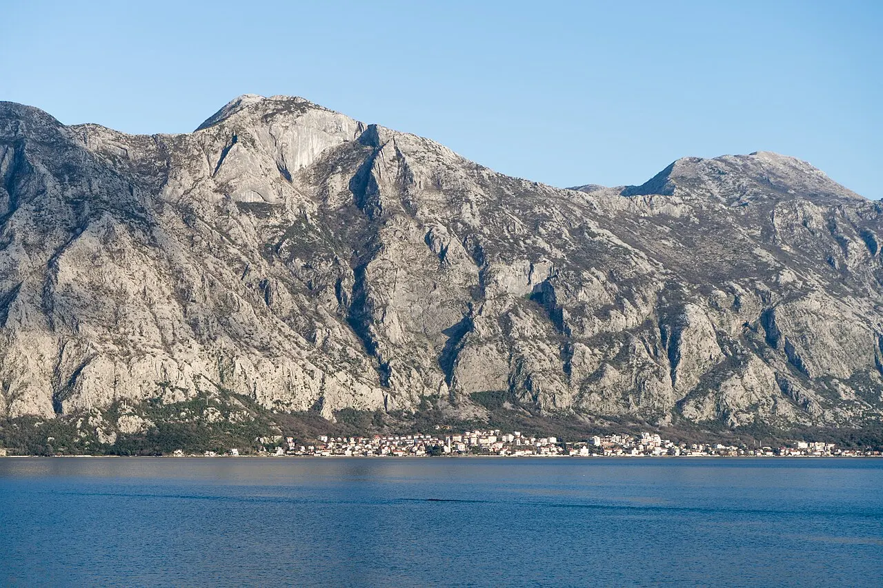
The Boka Kotorska was built for the scenic drive — though no one planned it that way. The bay is a ria, a flooded river canyon that folds inland in a chain of basins, with mountains rising almost vertically from the water's edge. The road has nowhere to go but along that edge, so for most of its length it runs at the very lip of the bay, the water on one side and stone walls or old houses on the other. The effect, from the driver's seat, is a near-continuous reveal: every headland opens a new view, and the famous walled town, the islands and the captains' villages all slide past your window.
That same geography is the catch. These are not fast roads. They are mostly two narrow lanes, threaded through villages and around tight headlands, shared with buses, scooters, cyclists and pedestrians, and they clog in summer. The trick to enjoying the bay by car is to treat the slowness as the point — to allow far more time than the short map distances suggest, drive gently, and stop often. What follows are the bay's best drives, with the photo stops, the traffic and the cautions for each.

The shoreline loop: Kotor, Perast and the captains' villages
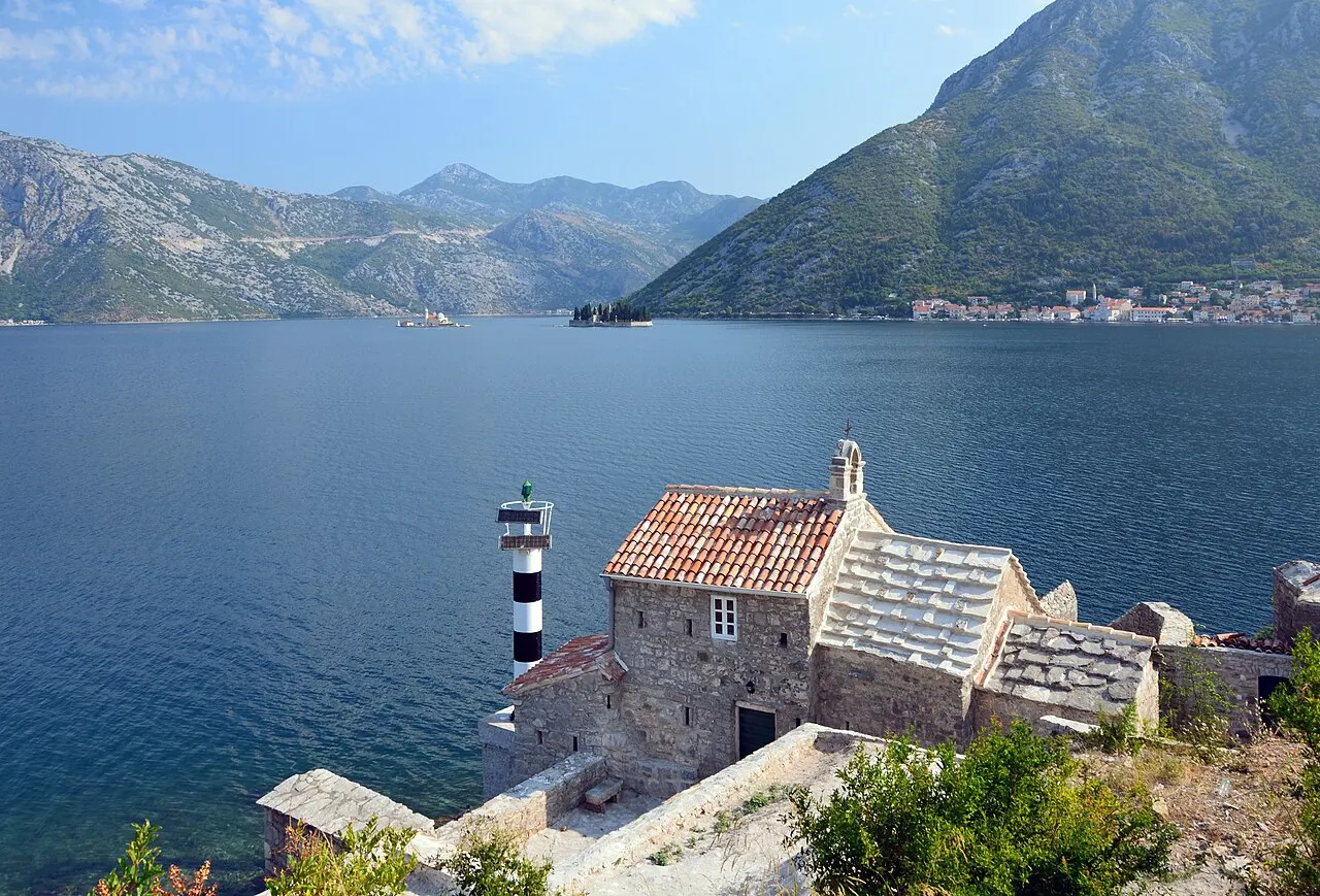
The signature drive is the loop around the inner bay. From Kotor the road runs north along the Dobrota waterfront, then on to Perast — the baroque captains' town strung along the water opposite its two island churches, and the natural place to stop, park and take a boat out to Our Lady of the Rocks. Beyond Perast the road curves round to Risan at the head of the bay, where Roman floor mosaics hide a short walk from the shore, then crosses to the opposite shore and returns along Prčanj and Stoliv back toward Kotor. The whole inner-bay circuit is short in kilometres but generous in views.
This is the gentlest of the bay drives — no big climbs, just the winding shoreline — which makes it the most relaxing way to see the captains' villages and the islands. Park sensibly: Perast keeps cars out of the town itself, with paid parking on the approach, so plan to walk in. Watch for the narrow squeezes where old stone houses pinch the road, and for pedestrians and parked cars on the village stretches. Build in time for Perast specifically; it deserves an unhurried stop rather than a drive-through.
- Route: Kotor → Dobrota → Perast → Risan, then back along Prčanj and Stoliv — the full inner-bay loop.
- Highlights: Perast and its islands, the Risan Roman mosaics, viewpoint after viewpoint along the water.
- Easiest of the bay drives — no big climbs, just the winding shoreline.
- Park on the approach to Perast (cars are kept out of the town) and watch the narrow village squeezes.
 Perast
The baroque captains' town that anchors the shoreline loop.
 Dobrota Promenade
Stretch your legs on the flat waterfront walk where the loop begins.
Map pins
Map data © OpenStreetMap contributors · Tiles © OpenFreeMap
The serpentine: Kotor to Njeguši and Lovćen
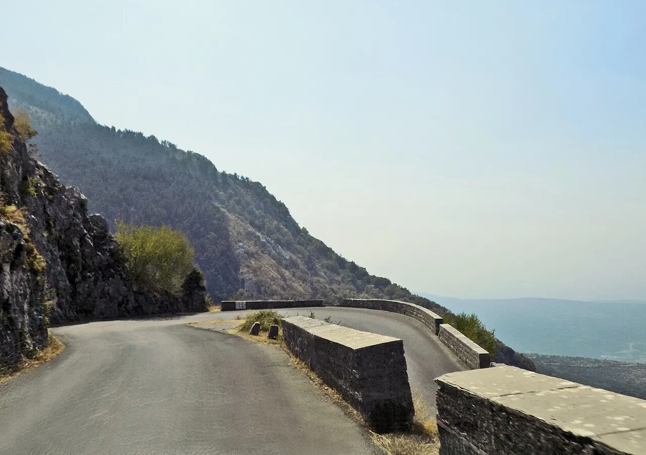
For the drive that everyone photographs, you leave the water and climb. The old serpentine road switchbacks dizzyingly up the mountain wall directly behind Kotor, coiling through a series of tight hairpin bends that stack one above the next. From the higher turns you look straight down on the walled town, the cruise ships and the whole inner bay laid out far below — arguably the single greatest aerial view in Montenegro, and the reason this road is on every drive-the-Balkans list. The road continues up to the mountain village of Njeguši, home of the region's famous prosciutto and cheese, and on into Lovćen National Park.
It is as demanding as it is beautiful. The hairpins are tight, some sections are narrow enough that two vehicles must take turns, and you will meet tour buses and coaches coming the other way on blind bends. Drive it in good weather and clear visibility, go slowly, use the horn on blind corners as the locals do, and let faster traffic pass at the laybys. Many travellers prefer to go up the serpentine and come down a different, easier route, or to skip the driving altogether on a guided tour. If heights and hairpins worry you, this is not the drive to force — verify the route's current condition and your own comfort before you commit.
- Route: the serpentine switchbacks from Kotor up to Njeguši and into Lovćen National Park.
- The payoff: the iconic aerial view straight down onto the walled town and the inner bay.
- Tight hairpins, narrow sections and oncoming buses on blind bends — drive slowly and use your horn.
- Best in clear weather; consider going up and coming down a different way, or taking a guided tour.
The ferry shortcut: Kamenari–Lepetane
Not every bay journey should be a full loop. The Kamenari–Lepetane ferry runs across the narrow mouth of the bay between the inner basins and the outer ones, and it is the great time-saver of driving the Boka. Taking it cuts out the long drive all the way around the inner bay when you are heading north toward Herceg Novi and Croatia, or out toward the Luštica peninsula — turning what can be an hour or more of winding shoreline road into a short hop across the water. The crossing itself is brief and frequent, and it doubles as a mini scenic moment, with views back into the bay as you cross.
It is a working car ferry rather than an excursion, so it simply slots into your drive. Frequency and the exact fare vary with the season and operator, and queues can build at peak times in summer, so verify the current timetable and price before you rely on it, and factor in some waiting at busy hours. Even with a short wait it usually beats driving around — and it is one of those small local logistics tricks that makes a Montenegro road trip flow.

- A working car ferry across the bay mouth between Kamenari and Lepetane — the bay's key driving shortcut.
- Saves the long inner-bay drive when heading north to Herceg Novi/Croatia or out to Luštica.
- Short, frequent crossing; a small scenic moment in itself.
- Frequency, fare and queues vary by season — verify the current timetable and allow for peak-time waits.

Out to the open coast: Tivat and Luštica
Beyond the inner bay, the drive opens up. The road over to Tivat — quickest via the Vrmac road tunnel that bores under the ridge — brings you to the broad Tivat bay, the superyacht marina of Porto Montenegro, and the airport. From there roads run out onto the Luštica peninsula, the green headland that closes off the bay toward the Adriatic, where you trade the enclosed inner-bay drama for open-sea horizons, sleepy villages and clear-water coves like Žanjice and the area around the Blue Cave. It is a different mood entirely: less hemmed-in, more Mediterranean.
These are easier roads than the serpentine but still want care: Luštica's lanes are narrow and quiet, and the run between Tivat, the ferry and Luštica can be combined into a loop with the Kamenari–Lepetane crossing. This stretch pairs naturally with a swim — the clearest open-sea bathing near Kotor is out this way — and with a longer day exploring the bay mouth and Herceg Novi. As always on the bay, the map distances flatter the reality, so allow time and verify any ferry or road details before you set off.
- Route: Kotor → Tivat (quickest via the Vrmac tunnel) → Luštica peninsula and the bay mouth.
- Highlights: Porto Montenegro's marina, open-sea horizons, and clear-water coves like Žanjice and the Blue Cave area.
- Easier than the serpentine but narrow and quiet on Luštica — combine with the ferry for a loop.
- Pairs naturally with the clearest open-sea swimming near Kotor.

Driving the bay: traffic, photo stops and cautions
A few habits make bay driving safer and more enjoyable. Treat summer like the high season it is: the shoreline road, Perast and the serpentine all clog from late morning through the afternoon, so the early hours and the evening are calmer and far better for both driving and photos. Park only in proper spaces — the villages have little room, and a badly parked car blocks a whole stretch — and resist stopping on the road itself for a photo. Use the marked laybys and viewpoints, which are positioned, conveniently, at the best vistas anyway.
Mind the specifics of mountain and shoreline driving: tight bends, oncoming buses, cyclists and pedestrians in the villages, the occasional unlit tunnel, and rain that can make the serpentine genuinely slippery. A horn tap on blind corners is normal and expected here. Carry water and keep the tank reasonably full, as services thin out on the higher and quieter roads. And keep your documents in order — Montenegro requires the usual licence, insurance and (with a hire car) the right paperwork. We keep volatile details such as ferry fares, fuel prices and exact timetables out of the prose because they change; verify them from official sources before you rely on them.
- Drive the bay early or in the evening — midday summer traffic clogs the shoreline, Perast and the serpentine.
- Stop only at proper laybys and viewpoints (which sit at the best vistas anyway) — never on the road itself.
- Expect tight bends, oncoming buses, cyclists and pedestrians; tap the horn on blind corners.
- Keep the tank full and carry water — services thin out on the higher, quieter roads.
- Verify ferry timetables/fares and current road conditions from official sources before you rely on them.

Bay of Kotor scenic drives at a glance
Use this quick card to pick your drive by mood. The roads, the views and the laybys are free and evergreen; the volatile details — ferry timetables and fares, fuel prices, parking charges and seasonal road conditions — change, so verify them from official sources before you set off.
- Easiest & most scenic: the inner-bay shoreline loop through Dobrota, Perast and Risan.
- Most thrilling: the Kotor–Njeguši–Lovćen serpentine for the iconic aerial view (tight hairpins, slow).
- Biggest shortcut: the Kamenari–Lepetane car ferry across the bay mouth — verify the timetable.
- Open-sea mood: Tivat and the Luštica peninsula via the Vrmac tunnel.
- Best timing: early morning or evening; avoid the midday summer crush.
- Golden rule: allow far more time than the map suggests, and stop only at proper laybys.
- Verify locally: ferry times/fares, fuel, parking and seasonal road conditions.

Bay of Kotor
How to explore the Bay of Kotor: the shape of the Boka's four linked basins, and the five ways to experience it — by boat, by bus, by car, on the waterfront on foot, and from a viewpoint above.
Read guidePerast
The baroque captains' town on the Bay of Kotor: its seafaring palaces and churches, the waterfront walk, St Nicholas and its bell tower, the boats to Our Lady of the Rocks, the Fašinada, and how to arrive, stay and eat.
Read guide
Njeguši & the Serpentine Road
How to plan the old serpentine road above Kotor to Njeguši — the hairpin climb out of the bay, the famous viewpoints, the pršut-and-cheese stop, when to go, who should drive it, and the traffic-rule caveats to verify.
Read guideMore in Things to Do
6
Aquarium Boka
Visit Aquarium Boka, Montenegro's public aquarium in Dobrota just north of Kotor's Old Town — what's inside, family timing, tickets, the species on show, and the flat bay-side walking route to reach it.
Read guideBeaches Near Kotor
Where to swim near Kotor: the honest truth about the inner-bay town beaches, the quieter bay swims at Dobrota, Prčanj, Stoliv and Muo, the clear-water Luštica coves like Žanjice, and the sandy options down the coast at Budva.
Read guideBest Tours in Kotor
Which Kotor tour to book and why: Old Town walking tours, the fortress climb guided or solo, bay boat trips to Perast and the Blue Cave, food and wine tours, Lovćen and Cetinje mountain day trips, cruise shore excursions, and private boats and yacht charters.
Read guide
Best Viewpoints in Kotor
The best viewpoints over the Bay of Kotor, ranked by effort and payoff — St John Fortress, the halfway church, the Ladder of Kotor, the cable car, the Vrmac ridge, the serpentine roadside pullouts and the angle from the water.
Read guide
Cats of Kotor
Why cats are part of the Kotor experience — the maritime backstory, where to find them in the Old Town, how to photograph and feed them responsibly, and the small charities that care for the bay's free-roaming cats.
Read guideDobrota Promenade
The waterfront walk north of Kotor: how to stroll, swim and café-hop along Dobrota's seaside promenade, past captains' palaces and bathing ladders, with the walled Old Town and the mountains across the bay the whole way.
Read guide