Bay of Kotor
How to explore the Bay of Kotor: the shape of the Boka's four linked basins, and the five ways to experience it — by boat, by bus, by car, on the waterfront on foot, and from a viewpoint above.

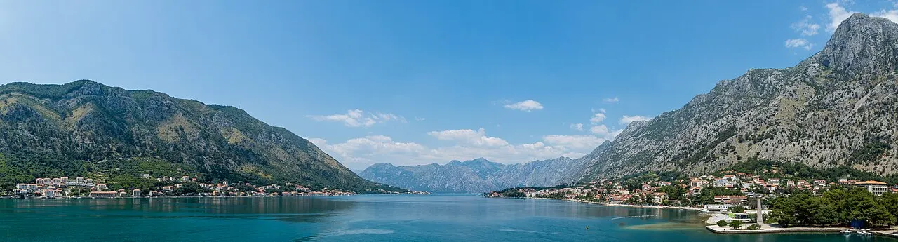
Photo: JinHui CHEN / Unsplash
- ✓The Bay of Kotor (Boka Kotorska) is a flooded river canyon — a ria, often called Europe's southernmost fjord — folding inland in four linked basins ringed by mountains.
- ✓Its narrowest pinch is the Verige strait, about 340 m across, where defensive chains were once strung to seal the inner bay.
- ✓There are five good ways to take it in: by boat, by bus along the shore, by car on the scenic roads, on foot along the waterfront, and from a viewpoint high above.
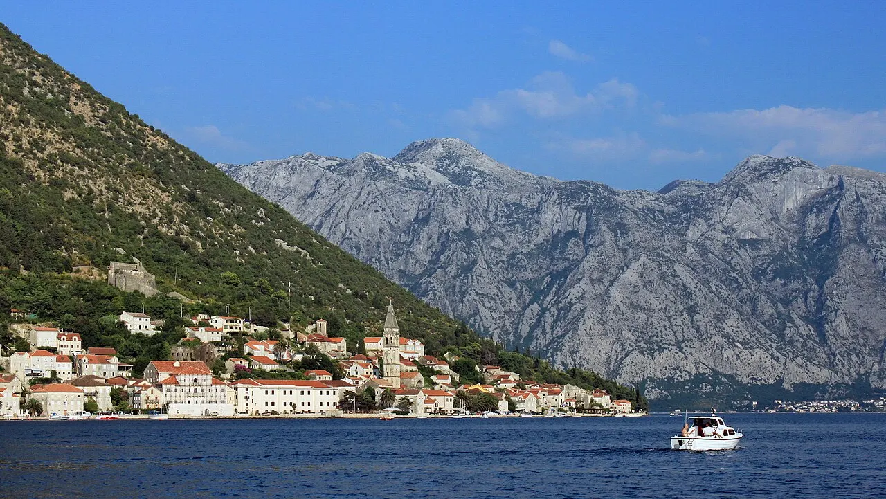
- ✓The headline stop is Perast and its island church, Our Lady of the Rocks; the captains' villages of Dobrota, Prčanj and Stoliv string along the shore.
- ✓The water stays calm, clear and swimmable into autumn, with bathing off ladders and platforms rather than broad sand.
- ✓Weather and season shape everything on the bay, so confirm boats, ferries and road conditions before building a day around them.
Say it like a local
Tap to hear each one spoken.
How the bay is shaped
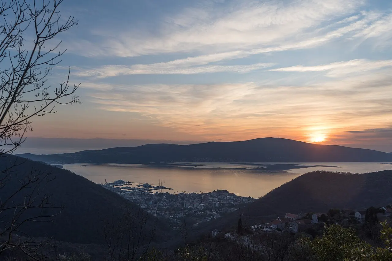
The Boka Kotorska is the great set piece of the Montenegrin coast, and understanding its shape unlocks the whole region. It is not a fjord in the geological sense but a ria — a river canyon drowned by the rising sea — which is why the mountains plunge so steeply to water that stays mirror-calm. The bay folds inland in a chain of four basins, linked by narrow straits, growing more enclosed and dramatic the deeper you go, until it ends beneath the cliffs of Lovćen with the walled town of Kotor tucked into its furthest, most theatrical corner.
That coiled, hidden geography is the whole appeal. Between the basins lies the Verige strait, the bay's narrowest pinch at around 340 m, where chains were once stretched across the water to bar enemy ships from the inner harbours. Around the shores sit the old maritime towns and captains' villages — Perast, Dobrota, Prčanj, Stoliv, Risan — and out toward the open sea lie Tivat, the Luštica peninsula and the bay mouth. The rest of this guide is the five best ways to experience all of it.
It helps to picture the layout before you go. The two inner basins — Kotor's and Risan's — are the dramatic, enclosed heart, where the cliffs press closest and the famous walled town sits at the dead end. The outer two — the Tivat bay and the wide Herceg Novi bay near the sea — are broader, sunnier and more open. The whole bay, with Kotor and its surroundings, has long been protected as a UNESCO World Heritage area for exactly this fusion of natural drama and centuries of maritime culture. Whichever way you choose to take it in, you are reading the same landscape the captains and pilgrims read before you.

By boat: the bay as it was meant to be seen
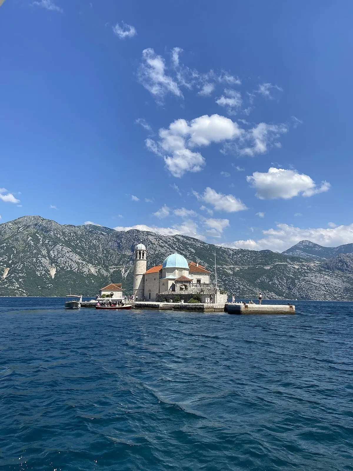
The bay was made to be read from the water, and a boat trip is the single best way to grasp it. The classic short run is to Perast and out to Our Lady of the Rocks, the man-made island church raised over centuries on sunken ships and votive stones — sheltered, story-rich and doable in a half-day. Longer group tours push past the bay mouth to the Blue Cave and the Luštica coves, where the sea glows electric blue and you can swim off the boat, though those depend on calm weather and can be cancelled in wind.
How you go on the water shapes the day. Group boat tours are frequent and inexpensive in season; private boats buy you the timing, the quiet and your own swim stops; and sunset cruises turn the bay golden for couples once the day traffic has gone home. Whatever you choose, confirm the operator and the weather window first — the sea decides everything out here.
 Bay of Kotor Boat Tours
Group, private and sunset trips — how to choose and what they cost.
 Romantic Kotor
Sunset cruises and private boats for couples on the bay.
Map pins
Map data © OpenStreetMap contributors · Tiles © OpenFreeMap
By bus, by car, and on foot
On land, you have three easy ways round the bay. The local buses that run along the shore between Kotor, Perast, Risan and the villages are the cheap, simple option — no parking to worry about, and the shoreline view from the window. By car you get the freedom to stop where you like: the scenic shoreline loop through the captains' villages, the white-knuckle serpentine up to Lovćen for the aerial view, and the Kamenari–Lepetane ferry shortcut across the bay mouth. Bay roads are narrow and slow in summer, so allow more time than the short map distances suggest.
And then there is the simplest pleasure of all: walking the waterfront. The flat promenade north of Kotor through Dobrota lets you stroll for kilometres at the very edge of the bay, past old palaces and bathing ladders, with the walled town and the mountains across the water the whole way. It is free, needs no booking, and is the loveliest easy thing to do on the bay.
- By bus: cheap and simple along the shore between Kotor, Perast, Risan and the villages.
- By car: the scenic loop, the Lovćen serpentine and the Kamenari–Lepetane ferry shortcut — allow extra time.
- On foot: the flat Dobrota promenade north of the Old Town, free and unbookable.


From above, and in the water
Two more ways round out the bay. From above, the viewpoints turn the whole geography into a single picture: the city walls climb above Kotor's Old Town, the serpentine bends on the road to Lovćen, the cable car up the mountain, and the quieter Vrmac ridge, which uniquely overlooks both the Kotor and Tivat bays at once. Time any of them for the golden hour and the bay glows beneath you.
And in the water itself: because the bay is a deep, sheltered ria, swimming here is calm, clear and easy — off the ladders and platforms of Dobrota, Prčanj, Muo and Stoliv rather than broad sand, with the clearest open-sea bathing out toward the Luštica coves. The water warms through the season and stays swimmable well into autumn, which makes a bay swim a reliable pleasure long after the high-summer crowds have thinned.
- From above: the city walls, the Lovćen serpentine, the cable car, and the two-bay Vrmac ridge.
- In the water: calm, clear bay swims off ladders and platforms at Dobrota, Prčanj, Muo and Stoliv.
- Clearest open-sea bathing is out toward the Luštica coves; the water stays swimmable into autumn.
Bay of Kotor at a glance
Use this quick card to plan how you take in the bay. The geography, the views and the waterfront walks are free and evergreen; the volatile details — boat and bus schedules, the Kamenari–Lepetane ferry timetable, prices and the day's weather and sea state — change, so verify them from official or on-the-ground sources before you rely on them.
- What it is: the Boka Kotorska, a flooded river canyon (ria) of four linked basins ringed by mountains.
- Narrowest point: the Verige strait, about 340 m across, where chains once sealed the inner bay.
- Five ways in: by boat, by bus, by car, on foot along the waterfront, and from a viewpoint above.
- Headline stops: Perast and Our Lady of the Rocks, the captains' villages, the Lovćen serpentine view.
- Swimming: calm, clear bay water off ladders and platforms; swimmable into autumn.
- Best timing: early or late in the day; spring and autumn over peak summer.
- Verify locally: boat, bus and ferry schedules, prices, and the day's weather and sea state.
More
17Bay of Kotor Boat Tours
Compare the kinds of boat trip on the Bay of Kotor: shared group tours, fast speedboat trips, private charters, the Perast and Our Lady of the Rocks classic, the Blue Cave route, and sunset cruises — what each suits, rough durations and the weather caveat.
Read guide
Best Swimming Spots in the Bay of Kotor
The best places to swim in the Bay of Kotor, compared by access, water, shade, families, boat traffic and view: the Dobrota platforms, the Muo and Prčanj rocks, the quiet Stoliv, Orahovac and Ljuta coves, and the clear-water Luštica beaches out toward the open sea.
Read guide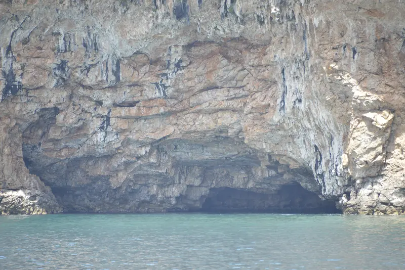
Blue Cave Montenegro
Is the Blue Cave (Plava Špilja) worth it from Kotor? What it is and why the water glows, where it sits near the bay mouth, how trips reach it, the sea-condition and timing realities, swimming inside, the crowds, and the honest verdict with alternatives.
Read guide
Kayaking & SUP in Kotor Bay
Where paddling works in the Bay of Kotor: the sheltered inner bay off Dobrota, Muo and Prčanj, the beginner-friendly routes, the all-important morning-wind safety rule, what to rent and which guided trips to join, and who kayaking and stand-up paddleboarding suit.
Read guide
Kotor Sunset Cruise Guide
When to book a sunset cruise in Kotor and what route to choose: why the bay is at its most beautiful at golden hour, the Perast run versus the open-bay loop, group boats versus going private, and how the high mountains change the sunset itself.
Read guide
Kotor to Perast by Boat
Every way to get from Kotor to Perast and Our Lady of the Rocks: boat tours (shared and private), the bay bus, taxi and driving — with steps, rough durations and the catch that there is no scheduled passenger ferry.
Read guide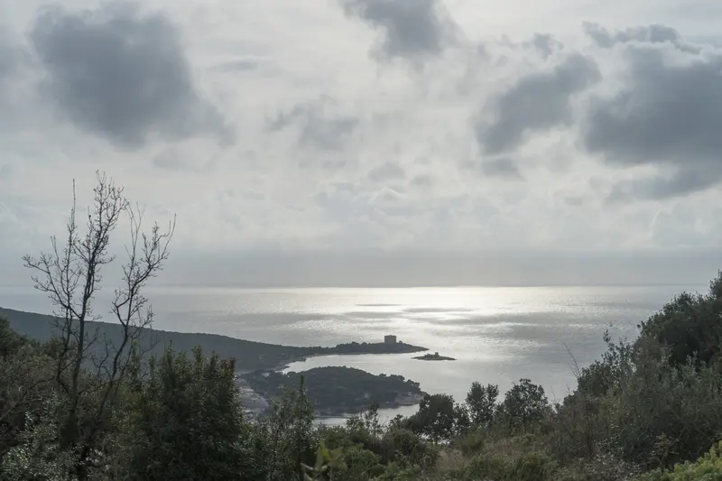
Luštica Peninsula
A guide to the Luštica peninsula at the mouth of the Bay of Kotor: its clear open-sea beaches and coves like Žanjice, Mirište and Rose, the Blue Cave, the quiet hill villages and olive groves, the drive-versus-boat decision, and when it's worth leaving the inner bay.
Read guide
Mamula Island
Understanding Mamula, the fortress island at the mouth of the Bay of Kotor: its Austro-Hungarian fort, its dark wartime past, the recent hotel conversion and the controversy around it, and how to see it from the water on a bay-mouth boat tour.
Read guide
Our Lady of the Rocks
A guide to Our Lady of the Rocks off Perast: the legend and the votive stones that built the islet, the 17th-century church, its icon, silver tablets and museum, the short boat across, the Fašinada ritual, and how to time and photograph a visit.
Read guide
Perast
The baroque captains' town on the Bay of Kotor: its seafaring palaces and churches, the waterfront walk, St Nicholas and its bell tower, the boats to Our Lady of the Rocks, the Fašinada, and how to arrive, stay and eat.
Read guide
Porto Montenegro, Tivat: A Visitor's Guide
How to visit Porto Montenegro in Tivat from Kotor: the superyacht marina and its waterfront promenade, the restaurants and boutiques, the Naval Heritage Collection and submarine, the luxury hotels, and how to fold it into a bay day.
Read guide
Private Boat Tours in Kotor
When a private boat is worth it on the Bay of Kotor — for couples, families, cruise passengers on a clock, photographers and groups who want the bay to themselves — what a charter buys you over a group tour, and how to choose and verify an operator.
Read guide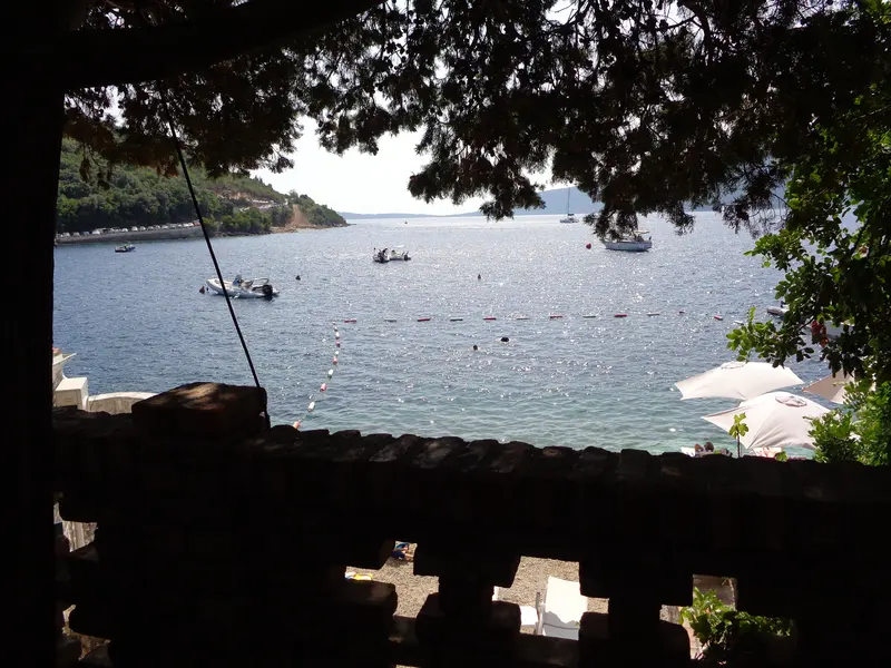
Rose Village
A guide to Rose, the quiet fishing village at the tip of the Luštica peninsula by the mouth of the Bay of Kotor: its slow boaty character, the swimming, the waterfront konobas, how to reach it, and why it suits a slower Boka day.
Read guide
St George Island, Perast
A guide to St George Island (Sveti Đorđe) off Perast: the cypress-clad natural islet with its Benedictine monastery, why it is closed to visitors, the legends and the 'Isle of the Dead' association, how it differs from Our Lady of the Rocks, and the best places to view and photograph it.
Read guide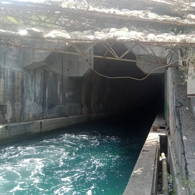
Submarine Tunnels of the Bay of Kotor
What the Bay of Kotor's old submarine tunnels are, the Yugoslav-navy history behind them, how boat tours actually visit these cliff-cut pens near the bay mouth, and the photo and safety context to know before you go.
Read guide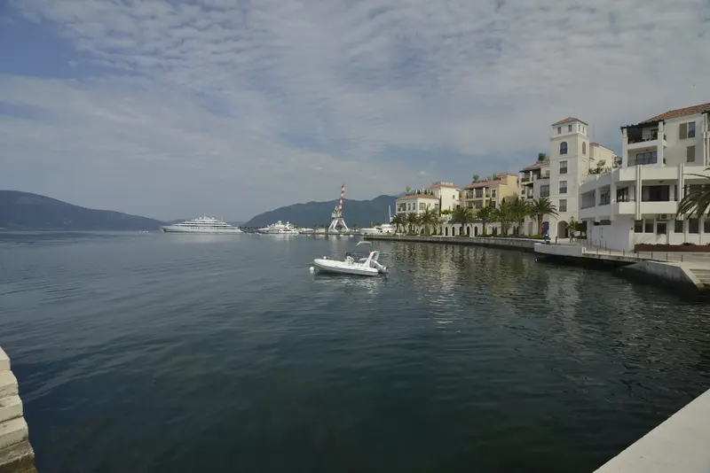
Tivat & Porto Montenegro from Kotor
How to day-trip from Kotor to Tivat and Porto Montenegro: getting there by bus, taxi, car or boat, what the glossy marina town is actually like, its beaches and airport-timing angle, and an honest verdict on when Tivat is worth a Kotor day.
Read guideŽanjice Beach
How to visit Žanjice from Kotor: the Luštica peninsula's best-known open-sea pebble cove — what it's like, reaching it by boat or by car, the crowds and best timing, the swimming, and how it pairs with the Blue Cave.
Read guide