
 Photo: Andrea Polereczky · CC BY-SA 3.0
Kotor to Durmitor Road Trip
Trade the bay for Ostrog, Žabljak, the seasonal Durmitor Ring and Tara Bridge on a four- to six-day mountain circuit.
- Allow
- 4–6 days
- Route
- 441 km
- Drive time
- 8 hr 26 min
- Stops
- 6
Montenegro’s scale is deceptive: Durmitor looks close to Kotor on a national map, yet the journey crosses deep valleys, working towns and weather systems. That transition—from maritime stone to the open plateau around Žabljak—is the reason to drive rather than merely transfer.
Base at least two nights in Žabljak and treat the 76-kilometre Durmitor Ring as a separate weather-dependent day. The ring is narrow, high and seasonal; it is not suitable for oversized vehicles or nervous improvisation. If local advice says no, walk near Black Lake and keep the circuit on main roads.
The road, in one glance
Pinch or scroll with Ctrl / ⌘ to zoom
Drawing the route…
The route earns
its distance
Each pin is selected as a place to do something—not merely proof that you passed through.
 Photo: User:Ggia · CC BY-SA 3.0
Kotor
Leave the bay with a full tank and no same-day mountain appointment forcing the pace.
Kotor, historically known as Cattaro, is a town in Coastal region of Montenegro. It is located in a secluded part of the Bay of Kotor. The city has a population of 13,347 and is the administrative center of Kotor Municipality.
 Photo: Diego Delso · CC BY-SA 3.0
Ostrog Monastery
A white monastery built into a vertical cliff creates the route’s most dramatic cultural stop.
The Ostrog Monastery is a Serbian Orthodox monastery near Danilovgrad, Montenegro. Situated against an almost vertical background, high up in the large rock of Ostroška Greda, it is dedicated to Saint Basil of Ostrog, who was buried here. Ostrog Monastery is the single most visited pilgrimage site within the Serbian Orthodox Church, receiving 1 to 1.2 million people annually.
 Photo: This image is a work by Mercy . When reusing, please credit me as: Mercy from Wikimedia Commons . I would appreciate being notified if you use my work outside Wikimedia. Do not copy this image illegally by ignoring the terms of the license below, as it is not in the public domain. If you would like special permission to use, license, or purchase the image please contact me to negotiate terms. More of my work can be found in my personal gallery . · CC BY-SA 3.0
Žabljak
The high town is the practical base for Durmitor, Black Lake and changing mountain weather.
Žabljak is a small town in the northern region of Montenegro. It has a population of 1,723. Žabljak is the seat of Žabljak Municipality (2011 population: 3,569).
Photo: Andrea Polereczky · CC BY-SA 3.0Durmitor Ring
A seasonal 76-kilometre panoramic road circles the massif through bare plateau, villages and high passes.
Durmitor is a massif located in northwestern Montenegro. It is part of the Dinaric Alps. Its highest peak, Bobotov Kuk, reaches a height of 2,523 meters (8,278 ft).
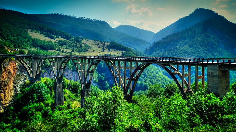 Photo: Daniel Borsos · CC BY-SA 3.0
Đurđevića Tara Bridge
The concrete arches span the Tara canyon and make the depth of northern Montenegro suddenly legible.
Đurđevića Tara Bridge is a five-arch concrete bridge spanning the Tara River canyon in northern Montenegro. Completed before the Second World War, it now serves both as a dramatic road crossing and as a high viewpoint into one of Europe's deepest river gorges.
 Photo: Pythonax · CC BY-SA 3.0
Kolašin
A compact mountain town provides a lower, greener overnight on the return toward the coast.
Kolašin is a town in northern Montenegro. It has a population of 2,418 (2023 census). Kolašin is the centre of Kolašin Municipality (population 9,949) and an unofficial centre of Morača region, named after Morača River.
Drive the conditions,
not the itinerary.
Check the Durmitor Ring locally on the day. Carry fuel margin, avoid darkness and expect livestock, cyclists and vehicles needing the whole lane.
Checked against
the people who run it
Distances and driving times are planning estimates. Conditions, closures, ferries, permits and park rules can change, so check the linked official guidance before setting out.